
What caught my attention wasn’t what it claims to do, it’s what it does instead of three different tools I was already juggling. Someone just open-sourced a full suite for tracking satellites and decoding their radio signals locally. You don’t even need the internet. It uses an SDR to pull weather images and raw data straight from space to your hard drive. 100% Open Source.
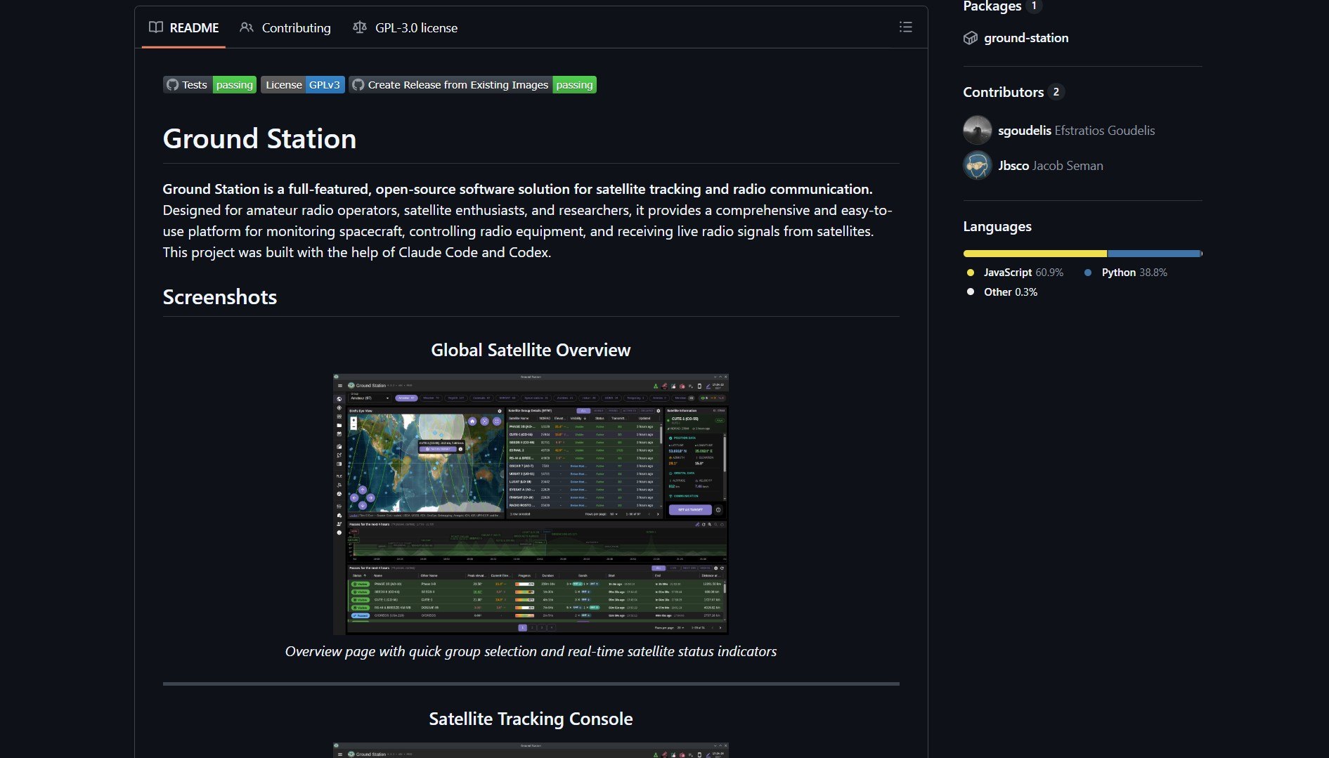
Ground Station is a full-featured, open-source software solution for satellite tracking and radio communication. Designed for amateur radio operators, satellite enthusiasts, and researchers, it provides a comprehensive and easy-to-use platform for monitoring spacecraft, controlling radio equipment, and receiving live radio signals from satellites. This project was built with the help of Claude Code and Codex.
What Is Ground Station?
Ground Station is a unified software suite that replaces the fragmented toolchain typically required for satellite tracking and signal reception. Instead of needing separate applications for orbital prediction, radio control, signal decoding, and data visualization, Ground Station integrates all these capabilities into a single, cohesive platform. It connects to Software-Defined Radio (SDR) hardware to capture signals directly from passing satellites, processes them locally, and presents actionable data—all without requiring an internet connection after initial setup.
Note: The “no internet required” aspect is revolutionary: once you have orbital data (which can be updated periodically), the entire pipeline—from signal reception to weather image generation—happens locally on your hardware, making it ideal for remote locations or privacy-conscious users.
Core Capabilities & Technical Architecture
| Component | Function | Technology |
|---|---|---|
| Satellite Tracking | Real-time orbital prediction and pass scheduling | SGP4/SDP4 propagation algorithms |
| Radio Control | Interface with SDR hardware (RTL-SDR, HackRF, etc.) | SoapySDR integration with multiple backends |
| Signal Decoding | Demodulation and decoding of satellite telemetry | Custom DSP pipelines for APT, LRPT, other formats |
| Data Visualization | Weather image rendering and telemetry display | OpenGL/WebGL for real-time rendering |
| Offline Operation | Complete local processing without cloud dependency | Local database for orbital elements and received data |
Key Features
- Complete Local Processing: Receive, decode, and display satellite data without internet connectivity.
- Multi-Satellite Support: Track and receive from weather satellites (NOAA, Meteor), amateur radio satellites, and more.
- Hardware Flexibility: Works with any SDR hardware supported by the SoapySDR ecosystem.
- Historical Data Archive: Store and review captured signals and images over time.
- AI-Assisted Development: Built with Claude Code and Codex, demonstrating AI’s role in complex system development.
- Cross-Platform: Runs on Windows, macOS, and Linux with consistent functionality.
Historical Context & Community Perspective
“I played with satellite stuff back in the 90’s. People were getting weather images. There were other satellites that were only overhead as they passed by. Used to pick them up on radio as they were near. Before the web existed…sat tracking data was sent over modems and you would crunch the data on the early pc’s we had then…or Commodore 20/64.” — @tomarsandbeyond1
This historical perspective highlights how far satellite reception technology has come while emphasizing what hasn’t changed: the fundamental appeal of pulling data directly from space. Where early enthusiasts needed specialized hardware, custom software, and significant technical expertise, Ground Station packages that same capability into an accessible, integrated solution that runs on modern hardware.
Why This Changes Satellite Reception Accessibility
Ground Station represents a democratization of satellite reception that mirrors the SDR revolution in radio. By combining previously disparate tools into a cohesive package and leveraging modern computing power, it makes satellite reception accessible to a much broader audience:
- Toolchain Consolidation: Replaces 3-5 separate applications with one integrated solution.
- Lowered Technical Barrier: Handles the complex signal processing and orbital mechanics transparently.
- Cost Reduction: Works with affordable SDR hardware (as low as $20-30) instead of specialized receivers.
- Educational Value: Provides a complete platform for learning about radio, satellites, and orbital mechanics.
- Research Utility: Offers a professional-grade toolset for academic and scientific satellite monitoring.
- Privacy Preservation: Local processing means your satellite reception activities aren’t logged on remote servers.
Project Link
Ground Station proves that sometimes the most powerful tools are those that unify rather than innovate. By bringing together decades of satellite reception knowledge into a single, well-designed package, it makes space-based data accessible to anyone with curiosity and a modest hardware investment.